Last Updated on 30 January 2026 by Johan
Stranda Municipality lies in Møre og Romsdal county in Western Norway, a region known for its dramatic fjords, steep mountains, and traditional rural culture. The municipality covers approximately 866 square kilometres and includes the villages of Stranda, Hellesylt, Geiranger, Liabygda, and the smaller settlement of Helsem. Stranda is the administrative centre and the largest village, with a population of around 2,500 residents. The entire municipality has roughly 4,500 inhabitants.
Stranda is internationally recognised for its spectacular natural scenery, especially the Geirangerfjord, one of Norway’s most visited fjords and part of the West Norwegian Fjords UNESCO World Heritage Site. Tourism, agriculture, food production, and small‑scale industry form the backbone of the local economy. The area is a year‑round destination, offering hiking, skiing, fjord cruises, and cultural experiences.
Geography and Nature
Stranda is situated between deep fjords and high alpine mountains. The most famous natural features include:
Geirangerfjord
The Geirangerfjord is one of the world’s most iconic fjords, known for its steep cliffs, abandoned mountain farms, and powerful waterfalls. It is part of the UNESCO World Heritage Site “West Norwegian Fjords,” inscribed in 2005. The fjord stretches approximately 15 kilometres and is surrounded by mountains rising up to 1,700 metres.
Waterfalls
Several waterfalls are major attractions:
- The Seven Sisters (De Syv Søstre): Seven parallel streams with a free fall of up to 250 metres.
- The Suitor (Friaren): Located opposite the Seven Sisters, tied to a local legend.
- Storseterfossen: A waterfall visitors can walk behind via a marked trail from Vesterås.
Mountain Peaks and Viewpoints
- Dalsnibba (1,476 m): One of Europe’s highest accessible viewpoints by road, offering panoramic views of the fjord and surrounding mountains.
- Flydalsjuvet: A dramatic viewpoint close to Geiranger.
- Ørnevegen (Eagle Road): A steep road with 11 hairpin bends leading to a viewpoint overlooking the fjord.
- Kvitegga and Hornindalsrokken: Popular peaks for experienced hikers and ski tourers.
Villages of Stranda Municipality
Stranda
Stranda village is the municipal centre and the main hub for services, shops, and accommodation. It is known for its food industry, including Norway’s largest frozen pizza producer and several traditional meat and dairy producers. The village has schools, sports facilities, and cultural venues.
Geiranger
Geiranger is one of Norway’s most visited tourist destinations. Despite having only around 300 permanent residents, it receives hundreds of thousands of visitors each year. Cruise ships frequently anchor here during summer, and the village offers hotels, restaurants, souvenir shops, and outdoor activity providers.
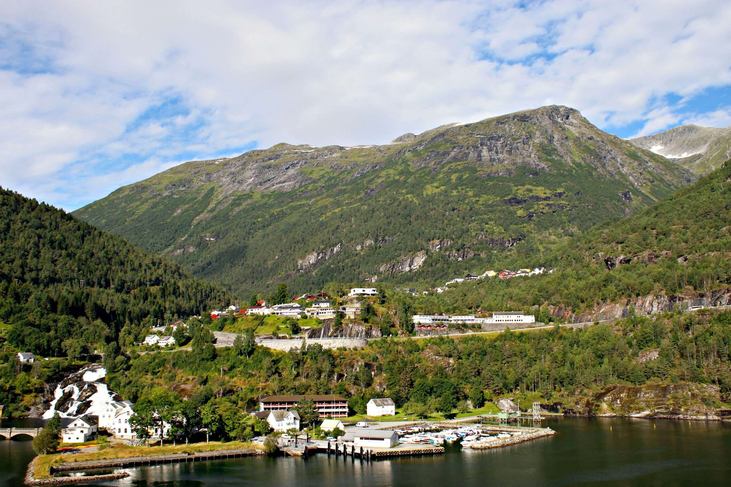
Hellesylt
Hellesylt lies at the head of the Sunnylvsfjord. The Hellesylt Waterfall runs through the centre of the village and is one of the most photographed waterfalls in the region. Hellesylt is the starting point for the ferry crossing to Geiranger during the summer season.
Liabygda and Helsem
These smaller settlements offer peaceful rural surroundings, traditional farms, and access to hiking trails and viewpoints.
History and Culture
Stranda has a long history of farming, fishing, and mountain agriculture. Many of the fjord farms, such as Skageflå and Knivsflå, were inhabited until the early 20th century. These farms are now preserved cultural sites accessible by boat and steep hiking trails.
The region has a strong cultural identity, with local festivals, traditional food production, and community organisations. Stranda is also part of the Sunnmøre district, known for its alpine landscapes and maritime heritage.
Tourism and Activities
Fjord Cruises
Fjord cruises operate from both Geiranger and Hellesylt during the summer. These tours offer close views of waterfalls, abandoned farms, and steep cliffs. The ferry between Hellesylt and Geiranger is a popular sightseeing route.
Hiking
Stranda offers hiking for all levels:
- Vesterås to Storseterfossen: A family‑friendly hike to a waterfall.
- Skageflå Farm: A steep but rewarding hike with fjord views.
- Dalsnibba: Accessible by road, but also part of longer hiking routes.
- Sunnmøre Alps: Challenging alpine terrain for experienced hikers.
Skiing
Strandafjellet Ski Resort is one of Western Norway’s most renowned ski areas. It offers:
- Six lifts
- Groomed slopes for all levels
- Off‑piste terrain with fjord views
- A gondola to Roaldshorn (1,230 m)
The Sunnmøre Alps are also a major destination for ski touring.
Fishing
Fishing is possible in fjords, rivers, and lakes. Recreational sea fishing does not require a licence for visitors in Norway. Cod, pollock, and haddock are common catches.
Cycling
Cycling routes include mountain roads, fjordside paths, and scenic climbs such as Ørnevegen. E‑bike rentals are available in Geiranger.
Driving and Scenic Routes
Norwegian Scenic Route Geiranger–Trollstigen passes through the municipality. This route includes dramatic viewpoints, mountain roads, and cultural landmarks.
Practical Information for Visitors to Stranda
Getting There
- By car: Stranda is accessible via regional roads from Ålesund, Åndalsnes, and Stryn.
- By ferry: Seasonal ferries operate between Hellesylt and Geiranger.
- By air: The nearest airport is Ålesund Airport Vigra, approximately 2 hours from Stranda.
Accommodation
Stranda offers hotels, cabins, campsites, and fjordside lodges. Geiranger has a wide range of accommodation options, including hotels with fjord views.
Climate
Stranda has a coastal climate with mild winters and cool summers. Weather can change quickly, especially in the mountains. Visitors should be prepared for rain and wind year‑round.
Electric Vehicle Travel
Norway is highly EV‑friendly. Charging stations are available in Stranda and Geiranger, including fast chargers near major hotels and tourist facilities.
Economy and Local Products
Stranda has a diverse economy:
- Agriculture: Dairy and meat production, including traditional cured lamb (fenalår).
- Food industry: Several well‑known Norwegian food brands operate here.
- Tourism: A major employer, especially in Geiranger.
- Crafts and small industries: Furniture, textiles, and mechanical workshops.
Local food products, especially cured meats and cheeses, are popular souvenirs.
UNESCO World Heritage Status
The West Norwegian Fjords, including Geirangerfjord, were added to the UNESCO World Heritage List in 2005. The designation recognises the fjords’ exceptional natural beauty and well‑preserved glacial landscapes. The area is protected to ensure sustainable tourism and conservation.
Tips for Tourists
- Book accommodation early during summer.
- Bring proper footwear for hiking.
- Check weather forecasts before mountain trips.
- Respect local nature and stay on marked trails.
- Consider visiting in spring or autumn for fewer crowds.
Conclusion
Stranda Municipality is one of Norway’s most scenic destinations, offering a combination of dramatic fjords, alpine mountains, cultural heritage, and year‑round outdoor activities. Whether you come for hiking, skiing, fjord cruises, or simply to enjoy the peaceful landscapes, Stranda provides an unforgettable experience rooted in authentic Norwegian nature and culture.
Sources
All information above is based on verified data from authoritative Norwegian sources:
- Stranda Municipality (official website): https://www.stranda.kommune.no
- Visit Norway (official tourism board): https://www.visitnorway.com
- UNESCO World Heritage Centre – West Norwegian Fjords:
https://whc.unesco.org/en/list/1195(whc.unesco.org in Bing) - Norwegian Scenic Routes (official): https://www.nasjonaleturistveger.no
- Norwegian Mapping Authority (Kartverket): https://www.kartverket.no
- Norwegian Meteorological Institute (weather): https://www.yr.no
- Statistisk sentralbyrå (Statistics Norway): https://www.ssb.no